Architecture, Engineering
& Construction
& Construction

Integrated BIM tools, including Revit, AutoCAD, and Civil 3D
Product Design
& Manufacturing
& Manufacturing

Professional CAD/CAM tools built on Inventor and AutoCAD
Connect data across your entire water system to monitor performance, respond to issues, and streamline compliance.
Autodesk® Info360 Insight is a cloud-based operational analytics and digital twin solution for water and wastewater utilities. It brings together data from networks and treatment plants to help teams:
Monitor performance and detect issues in real time.
Streamline compliance reporting with automated tools.
Improve model calibration with direct InfoWater Pro integration.
Autodesk Info360 Insight overview (video: 2:18 mins)
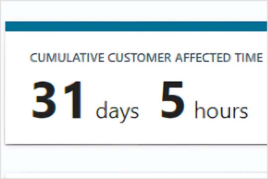
Report showing incident impact assessment
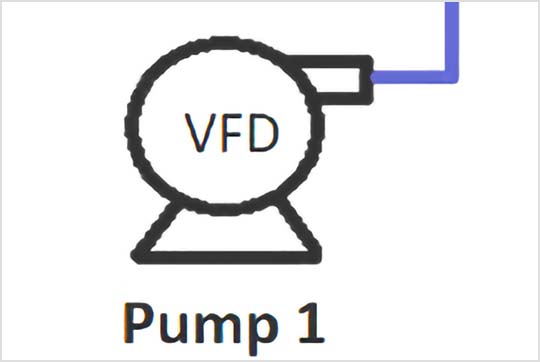
Wastewater pump station workspace
Incident Manager screen with incident and response timeline
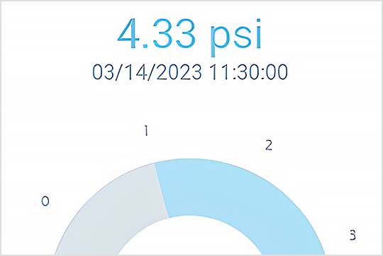
Operational analytics screen showing pressure and usage data
Real-time wastewater data and analytics
Optimise operations to reduce energy use, water loss, and downtime.
Detect and resolve network and plant issues before they escalate.
Automate compliance tasks and reduce time spent on paperwork.
Use accurate insights to forecast needs and guide system decisions.
Connect live SCADA data with InfoWater Pro to automate calibration (video: 1:11 min.)
Connect Info360 Insight with InfoWater Pro to automate model calibration. Keep models near real-time with live data and cleansing tools—supporting faster calibration, more accurate forecasts, and stronger capital planning decisions.
Impact on customers during an incident (video: 32 secs)
Quickly identify affected customers with simulation generation of an incident's impact. Run what-if scenarios for outage management and get an incident resolution timeline, unifying response teams with a common operating picture.
Automated compliance reporting (video: 1:01 min.)
Automate calculations, formatting, and report generation to meet evolving regulations. Eliminate manual spreadsheets and cut compliance reporting from weeks to days.
CUSTOMER STORY
Learn how Stantec helped save Wellington Water 20% in electricity costs.
BLOG
Discover why and how you can build a water data culture with low-code/no-code analytics tools to scale your domain expertise.
PUBLIC ROADMAP
View the online public roadmap to confidently adopt Info360 cloud solutions.
Autodesk® Info360 Insight is a cloud-based operational analytics and digital twin platform for water and wastewater utilities. It is used to monitor networks and treatment plants in real time, detect and resolve incidents faster, streamline compliance reporting, and support better decision-making with accurate data and scenario modelling.
Autodesk Info360 Insight is used by water and wastewater utility operations teams, field teams, engineers, managers and executive-level decision makers alongside expertise from trusted consulting companies and industry specialists to improve service delivery, maximise operations and business resources, and rapidly manage incident response.
Yes. Info360 Insight connects directly with InfoWater Pro to streamline model calibration workflows. Utilities can align live operational data with hydraulic models, improving accuracy, speeding up engineering workflows, and strengthening planning decisions. Learn more about this integrated workflow on the One Water Blog.
To start with Info360 Insight, log in to info360.com using your Autodesk account credentials and your company domain name. Ensure there's a valid Info360 Insight product subscription for your team on your Autodesk account and that you are assigned as an Admin. Then, create a hub for your team from the Autodesk Account (manage.autodesk.com). If multiple teams exist, each requires a hub. Once the hub is created and Info360 Insight activated, you will be redirected to the Info360 Insight page.
Key help file links:
To import data into Info360 Insight, identify the data sources for your networks and install the Info360 Insight Data Connector. Next, configure your database connection in Info360 Insight. Identify and upload the sensors in your water and wastewater networks that you want to monitor and analyse. You can do this in bulk using a CSV template. Finally, upload your utility network for full spatial context. This can be done via GeoJSON files or by integrating with ArcGIS Online. Once completed, sensor data will populate into Info360 Insight.
Key help file link: